One third of Americans (115 million people) live in counties at high risk of wildfire. But how people prepare and respond to wildfires can make a big difference to the number of blazes, the damage done, and the air we breathe.
This work begins by reducing the risk of wildfire in the first place. If the conditions for wildfires to start and spread are due to climate change more generally, the spark that ignites them is increasingly the result of individual or corporate carelessness.
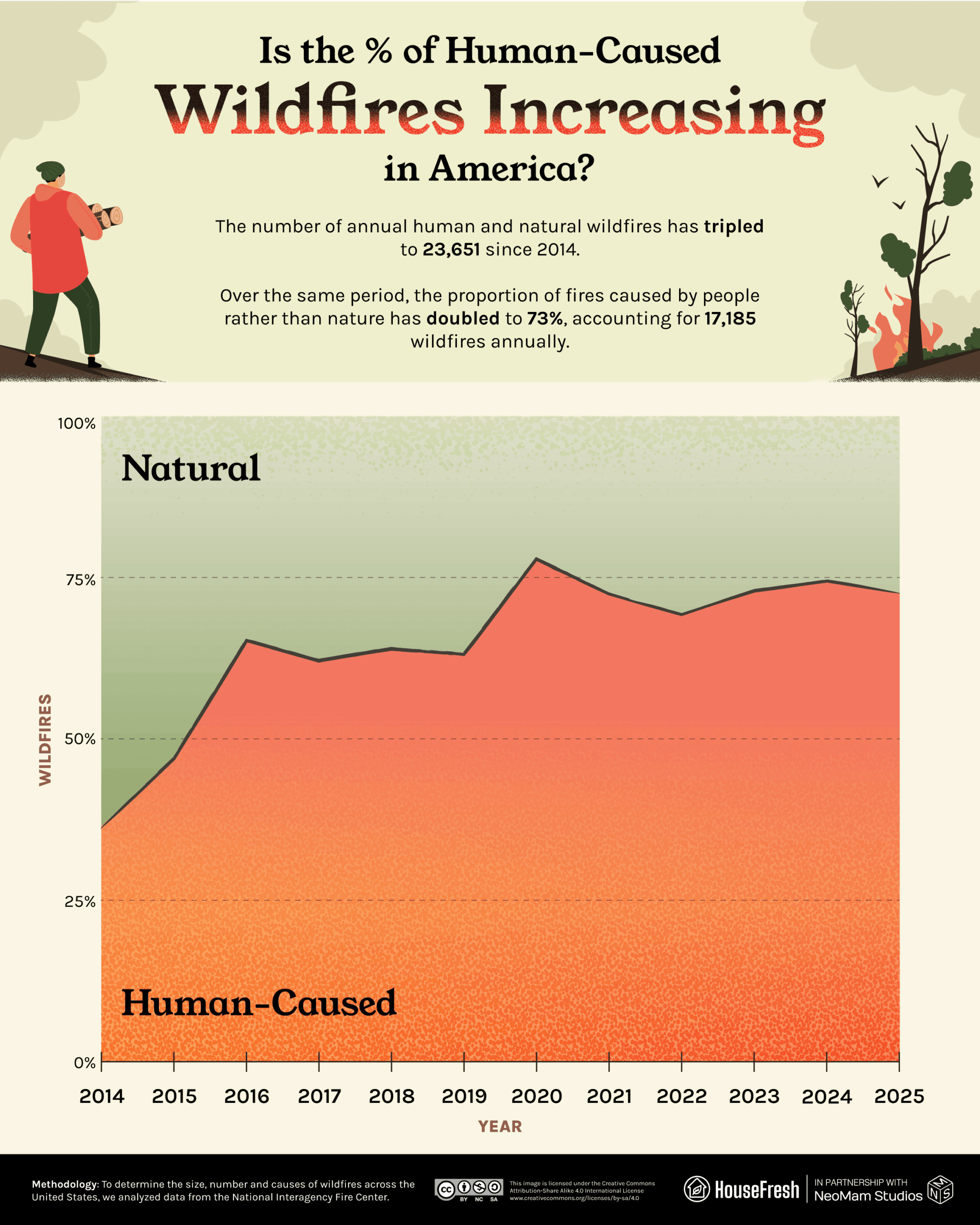
Specifically, we have found that the percentage of wildfires caused by humans has risen from 37% to 73% since 2014, as per data from the National Interagency Fire Center (NIFC).
The evidence suggests that by taking better care and improving conditions in and around the home, people can protect their families and their environment. But where are wildfires most prevalent, and how can we defend against fire and smoke?
We gathered and analyzed 2025 data from the National Interagency Fire Center, the U.S. Air Quality Index (AirNow), Air Quality Management District (AQMD) agencies, and the Centers for Disease Control and Prevention (CDC) to determine the size, number and causes of wildfires across the United States. We also ranked U.S. states and counties by total acres burned in 2025.
Key findings
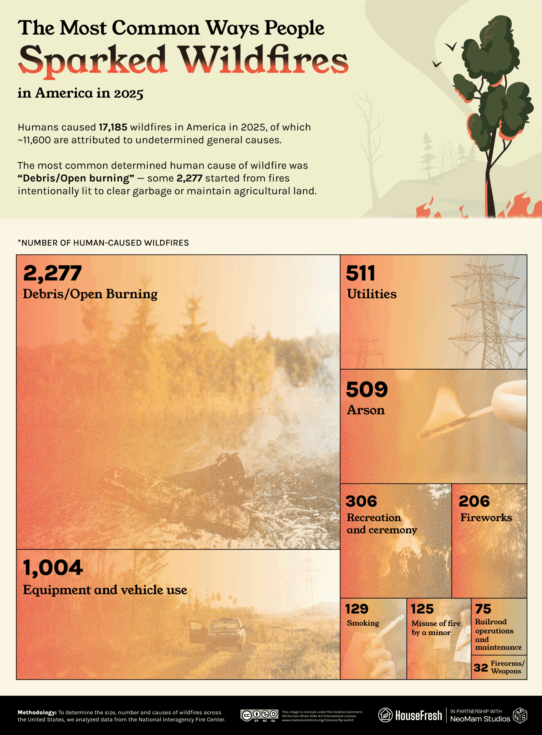
- Of around 17,185 human-caused wildfires in 2025, the precise cause is known in ~5,174 cases.
- Of the fires with known causes, 2,277 were caused by Debris/Open Burning (intentionally lit to clear garbage or maintain agricultural land) — the leading known human cause.
- In 2025, 73% of U.S. wildfires with a known cause were attributed to humans rather than nature. This is double the amount in 2014 (37%).
- The states with the most total acreage burned by wildfire in 2025 were Alaska (1,006,183 acres), California (524,899) and Nevada (396,627).
- In the U.S., the effects of wildfire smoke kill around 40,000 people each year — the same number that die in vehicular crashes.
The most common human causes of wildfires in America
The proportion of fires caused by people rather than nature has doubled in 10 years.
We analyzed the latest available data from the National Interagency Fire Center (NIFC) to examine how people and organizations are responsible for individual fires, and how the number of human-caused wildfires measures up against those that occur naturally.
We found that of around 17,185 human-caused wildfires in 2025, around 11,600 were attributed to undetermined general human causes. Of those for which a precise human cause has been determined, by far the most prevalent causes are Debris/Open Burning (2,277 wildfires) and Equipment and vehicle use (1,004). You can see the top 10 human causes of wildfires below.
Open Burning refers to the “burning of any materials wherein air contaminants resulting from combustion are emitted directly into the ambient air without passing through a stack or chimney.” It includes yard fires and trash burning. Some open burning of natural waste is permissible in certain areas and at certain times, with a permit and adherence to safety protocols. Indeed, correctly done, the “controlled burning” of natural debris can actually reduce the impact of wildfire by creating low-ignition buffer zones.
In addition to the risk of wildfire, the World Health Organization reports that the “climate impact of black carbon emitted from open burning of waste is equivalent to 2–10% of global CO2eq emissions” and that these pollutants “may result in acute health effects including eye and nose irritation, difficulty breathing, coughing and headaches, as well as respiratory infections.”
The NIFC data also show that open-burning and other human-caused wildfires have risen in proportion to naturally occurring wildfires since 2014. The human share has risen from 37% in 2014 to 73% in 2025, peaking at 78% in 2020 and hovering around the low- to mid-70s through the first half of the 2020s.
Why are humans causing a greater proportion of U.S. wildfires than a decade ago? In part, it’s because more extreme climate conditions make the landscape more susceptible to the kinds of wildfires humans spark. While lightning fires occur in rainy weather, human ones are more likely to start in dry or windy conditions and spread much faster.
Humans have also developed more land during this time, particularly in more vulnerable places, expanding the wildland–urban interface (WUI) — the areas where urban structures, flammable vegetation and human behaviors meet. Under these conditions, “there will be more wildfires due to human ignitions,” as one University of California paper lays it out, and “wildfires that occur will pose a greater risk to lives and homes, they will be hard to fight, and letting natural fires burn becomes impossible.”
Visualizing the scale of wildfires by state
Alaska lost nearly twice as much land as any other state to wildfire in 2025.
Alaska (1,006,183 acres) was the worst-hit state, suffering 1.92 times the total acreage burned of second-worst California (524,899 acres).
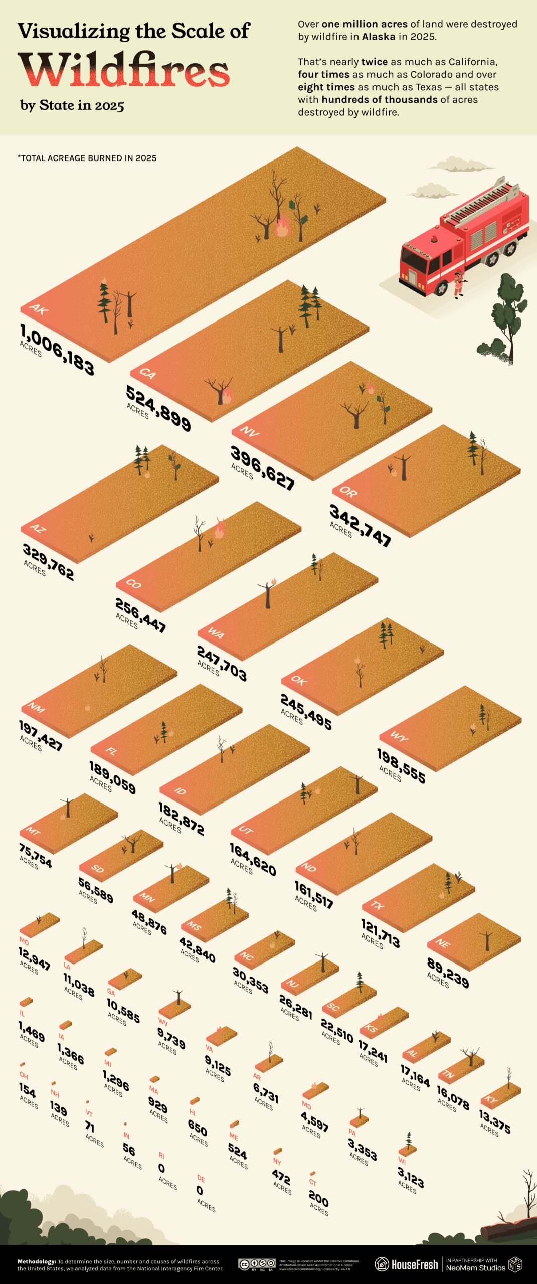
Wildfire is particularly prevalent in Alaska at the height of summer when parts of the state experience nearly round-the-clock daylight. But snow levels were particularly low in Spring 2025 in Alaska, prompting authorities to extend the wildfire season. Along with Alaska’s expanding wildland–urban interface, longer growing seasons contribute to more flammable conditions.
Indeed, over half of Alaska’s wildfires are attributed to lightning strikes, which become more common under hotter, drier conditions. The Department of Agriculture notes that in the first two decades of the 21st century, “2.5 times more acres burned than in the previous 20 years” and that “3 of the 4 highest-acreage fire years have occurred since 2000” in Alaska.
Visualizing the scale of wildfires by county
Four of the ten worst-hit counties are in Alaska, with the county of Yukon-Koyukuk suffering the most damage: 607,806 acres.
Outside of Alaska, Nevada’s Elko County saw the most burned acreage in 2025, losing over a quarter million acres (273,470 acres) to wildfire. An unusually dry June and active thunderstorm season led to the largest wildfire season since 2020.
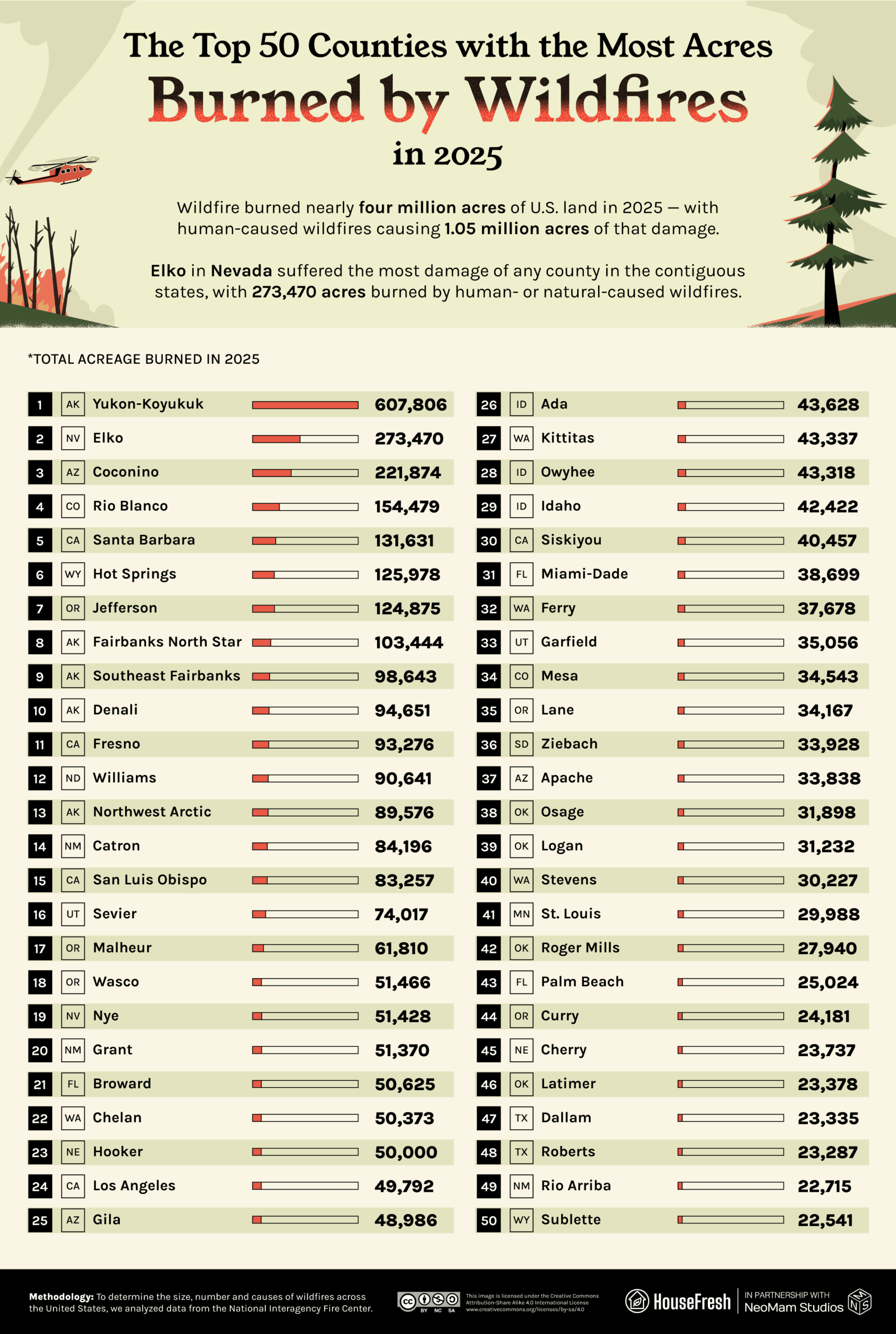
A lot of Elko’s trouble is emblematic of how the delicate balance of the climate modulates the risk of wildfire. Healthy snowfall the previous year put an end to wildfire season, but, in melting off nurtured an expansive and flammable growth of cheatgrass that exacerbated conditions in 2025. And the same thunderstorms that can extinguish fires if they’re rainy enough spark wildfires if they’re not.
How bad is wildfire smoke for your health?
Flames and destruction may grab the headlines, but wildfire smoke has devastating effects. Not only does it further compound the very issue — climate change — that contributed to the fire in the first place, but it spreads far from its source and into homes and schools, apparently safe from the primary effects of the fire.
Here are five ways that wildfire smoke can affect your and your loved ones’ health.
| Respiratory illness | Inhaling fine particles irritates your lungs and airways. This can cause coughing or difficulty breathing, and worsen issues such as asthma or chronic obstructive pulmonary disease (COPD). |
| Cardiovascular issues | Particles can get into your bloodstream, triggering inflammation that can lead to heart failure, heart attack or stroke. |
| Developmental damage | Breathing poor air, including wildfire smoke, can slow a baby’s development and increase the risk of asthma. One study suggests that wildfire exposure can cause cell damage to first- and second-trimester placentas. |
| Higher risk of infection | Inhaled particles from wildfire smoke may impact your body’s ability to expel “inhaled foreign materials,” including viruses and bacteria. |
| Impaired cognition | Like traffic pollution, wildfire smoke has been linked with poorer learning outcomes for children, possibly due to changed breathing rates. |
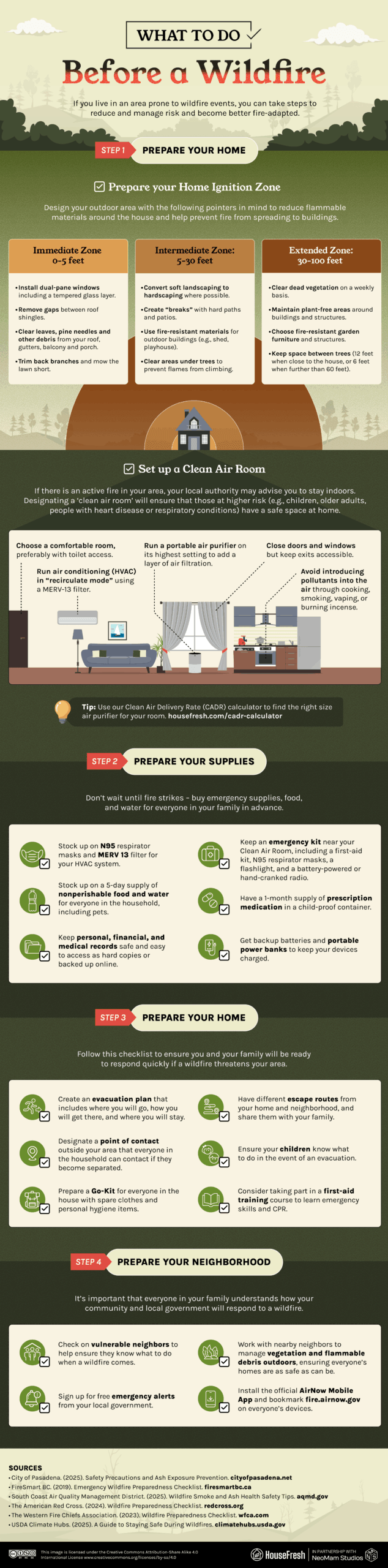
How to prepare for a wildfire
Reduce potential damage by figuring out your risk level and preparing your home and family.
Ahead of wildfire season, it is essential to research and prepare to protect your health and property. Online tools can help you ascertain your area’s general risk of wildfire, and you can sign up for alerts from local or tribal organizations for immediate warnings.
Our checklist below outlines the steps to make your family and home wildfire-ready. These include actions to mitigate the effects of wildfire as it approaches your property, both to protect your home and to help prevent further spread, and to know the steps in advance should you need to evacuate.
In the U.S., the effects of wildfire smoke kill around 40,000 people annually — the same number that die in vehicular crashes. And wildfire smoke spreads much further and lingers longer than the flames. As such, it should be a priority to research and prepare to protect your family from wildfire smoke.
It is also essential to maintain supplies in advance of a wildfire striking. This is especially true for MERV 13 filters for your HVAC system and N95 respirator masks for your family. We haven’t tested N95 masks ourselves, but Breathe Safe Air has reviewed the best masks for kids and teens.
You should also know where to find updates and warnings when wildfires are in your area. This video from the Environmental Protection Agency (EPA) is a good primer.
What to do during a wildfire
Evacuate if told, and if you stay, focus on keeping your indoor air clean.
Wildfire can spread faster than the average person runs and can jump and change direction suddenly in the wind. The U.S. Fire Administration warns that “today’s structure fires can go from a small flame to flashover in just 3 to 5 minutes, leaving little time for escape.”
Wildfire smoke can quickly spread with the wind and may cause harmful health effects even if it doesn’t appear to be dangerous.
Even if your home is not in immediate danger from blazes, it is important to take steps against the threat of smoke. Here is our full checklist of what to do when wildfire strikes.
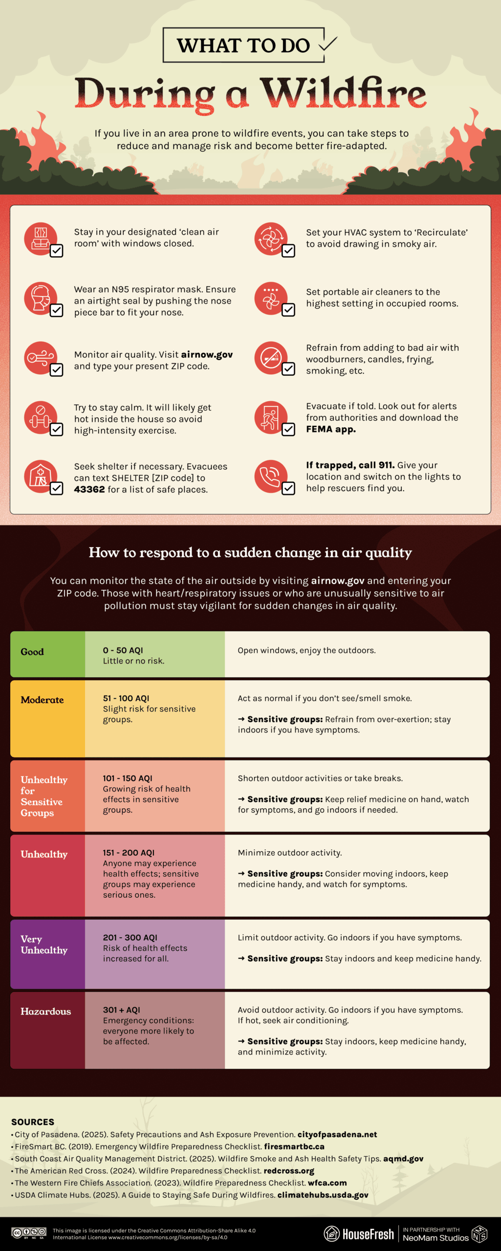
If there is smoke in the air around you, it’s time to keep children indoors, run your HVAC system and wear a mask (adults only). If you don’t have N95 masks on hand, use “the best available mask you have access to,” says Dr. James McDonald, commissioner of New York State’s Department of Health. “If you have a surgical mask, that will give you some protection, but N95 and KN95 are better masks to use in times like this.” Note that while such respirator masks filter out fine particles in the smoke, they do not protect against hazardous gases.
Keep windows closed, run your HVAC system with high-efficiency filters (MERV-13 or higher), and replace the filters regularly. Use the “recirculate” mode or an equivalent to prevent it from drawing in outside air, and run your portable air cleaner continuously.
If you have a clean air room, have the kids play in there, and keep it cool by closing the window shades and using fans. Avoid strenuous games and activities or activities that may worsen air quality, such as frying or vacuuming.
What to do after a wildfire
Maintain caution while danger lingers, and look out for signs of mental distress.
Even when the wildfire has passed, danger may remain. Evacuees should reapproach their home with caution and only when instructed that it’s safe to return. The building, surroundings and air can still hold threats, and children should be watched carefully and kept from playing with ash or debris. And when it comes to the clean-up, there are proper techniques and safety procedures to follow. Children should not assist.
In addition to the precautions below, those returning to an evacuated home should be aware of what they eat and drink. If a fridge or freezer has lost power, throw away food that’s been at room temperature or higher for more than two hours.
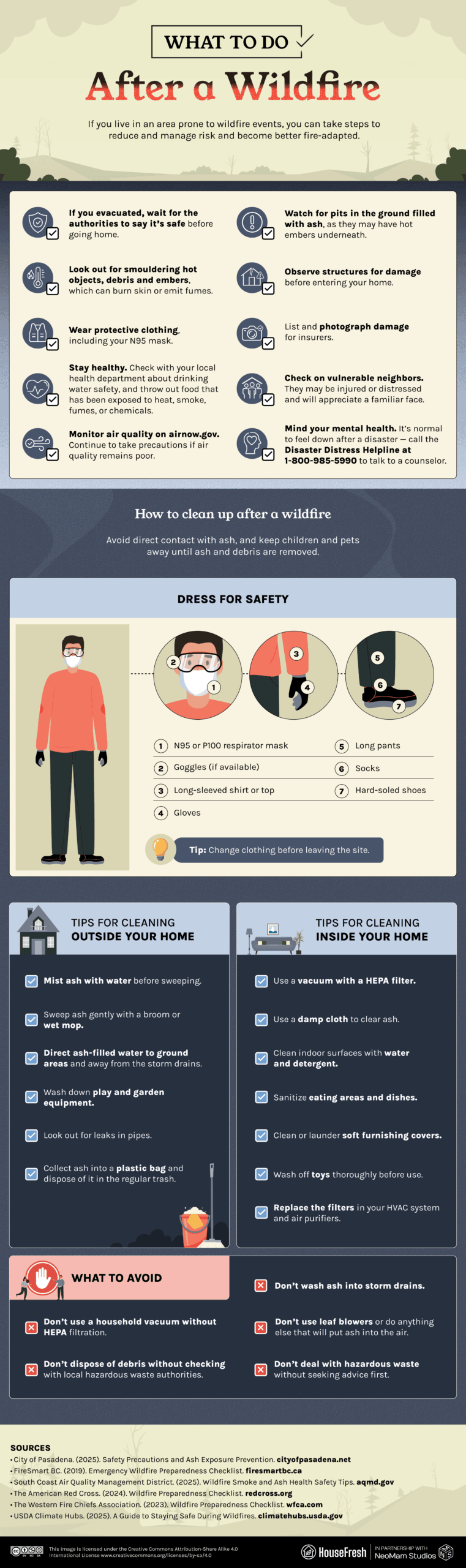
Experts advise continuing to wear a mask in the aftermath of a local wildfire. Even if the air has returned to “safe” AQI levels, some hazardous particles may not be picked up by AQI sensors, or the sensors may be inadequate for your precise location.
It is very normal to feel sad or distressed after a wildfire has passed. Look out for symptoms of trauma or depression in yourself and others, and talk to your children about what’s happened to help them to process events and flag potential issues.
Final thoughts on wildfires
The threat of wildfire is not going away, and efforts to improve conditions are multi-pronged.
On the one hand, authorities must work with corporations and communities to temper the effects of climate change and strategize around environmental protection, wildfire management, and recovery. Land authorities are also taking proactive steps to engage with wildfire in progressive ways, such as the Yukon Flats National Wildlife Refuge, which is prioritizing the protection of carbon-rich areas of permafrost when fire strikes — both to limit the wildfire and to limit the further release of carbon, which would exacerbate climate change.
At the same time, individuals must take responsibility for reducing the disproportionate number of human-caused wildfires in the U.S. annually. In Elko, for instance, hunting season leads to the frequent ignition of dry vegetation by stray sparks, while other leisure activities also have an impact. “The thing that helps the most is not driving off-road. High grass building up under vehicles – hot mufflers hitting grass – can result in a fire. Make sure you have a shovel and water with you if you’re going to have a campfire,” says Brock Uhlig, State Fire Management Officer for BLM Nevada.
But the need to protect your lungs, family, and property remains paramount. And while knowing what to do when fire strikes can save lives, efforts to prepare your family’s safety can begin today.
METHODOLOGY
To determine the size, number and causes of wildfires across the United States, we reviewed data from the National Interagency Fire Center. The causes of wildfires were ranked based on the number of wildfire incidents in 2025. States and counties were ranked based on total acres of land burned due to wildfire in 2025. Data is correct as of April 2026.